


The California Aqueduct
Slideshow by Aquafornia
Come take a trip and follow the water as it flows from the Delta to Southern California!
35386 views since April 20, 2008.
Get a link button for this slideshow »
Make and share your own slideshow »
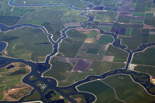
1 of 33
2007_07_25_sfo-den-bos024.JPG
The Delta is located east of the San Francisco Bay Area at the confluence of the Sacramento-San Joaquin Rivers. The Delta forms the eastern portion of the San Francisco estuary, which includes the San Francisco, San Pablo, and Suisun Bays. The Delta encompasses 738,000 acres, stretching inland nearly 50 miles. It includes portions of Sacramento and West Sacramento at its northern point, down to Tracy at its southern point, and spanning 25 miles from Antioch to Stockton. Five rivers flow into the Delta area, accounting for nearly half the snowmelt and runoff of the entire state. It is also home to over 750 different plant and animal species.
Photo by dsearls
2 of 33
Sacramento River
Nearly half of the states runoff from five major rivers empty into the Delta , and over two-thirds of California?s population, or 23 million people, get a portion or all of their drinking water from water projects flowing through the Delta. Water from the Delta is also used to irrigate millions of acres of prime farmland, supporting the nations #1 agricultural area and pumping $27 billion into the state's economy.
Photo by Aquafornia
3 of 33
Bullfrog Landing
The Delta is a popular recreation area, offering camping, hiking, bicycling, hunting and horseback riding. The labyrinth of the sloughs and waterways of the Delta are lush with vegetation, and offer boating, water skiing and fishing opportunities. Delta waterways are said to offer some of the finest boating opportunities in the country. There are over 100 marinas and waterside resorts, RV Parks, grocery stores and dock-side restaurants, and houseboating remains popular. There are numerous public parks and fishing sites as well.
Photo by Aquafornia
4 of 33
Fishing in the Delta
The Delta supports a vibrant fishery for both recreation and commercial purposes. Eighty percent of the state?s commercial fishery species either live in or migrate through the Delta, including four Salmon runs, sturgeon, stripers, and bass. The Delta is home to a vibrant diversity of wildlife and birds, including millions of migratory birds and ducks who stop over on one of the last remaining wetland areas on the California coast.
However, this year due to drastically low numbers of returning Chinook salmon, the salmon fishing season was closed.
Photo by Aquafornia
5 of 33
Delta Irrigation Canal
Once a vast marsh, unsuccessful miners turned to farming and began draining and reclaiming the land in the mid 1800?s, encouraged by federal swampland reclamation laws and the Delta?s rich, fertile peat soil. Levees were built, creating islands of productive farms, and by 1900, 250,000 acres had been reclaimed. Over the next thirty years, the amount of reclaimed land grew to nearly 450,000 acres, creating one of country's most productive agricultural regions.
Photo by Aquafornia
6 of 33
Intake gates at Clifton Court Forebay
The water from the Delta flows into the intake channel through intake gates from the Clifton Court Forebay on it's way to the Harvey O. Banks Pumping Facility. This channel is huge - 30 feet deep, 40 feet wide at the bottom and 138 feet at its top.
Photo by Aquafornia
7 of 33
Intake channel for the California aqueduct
The water heads first to the Skinner Fish Facility, where fish are removed from the intake channel and returned to the Delta. The water then heads on to the Harvey O. Banks Pumping Plant and the beginning of the California Aqueduct.
Photo by Aquafornia
8 of 33
Harvey O. Banks Pumping Facility
The Harvey O. Banks Pumping Facility lifts the water 244 feet into the California Aqueduct. The 11 pumps are capable of pumping 21,000 acre-feet or from 4 to 6.7 billion gallons of water per day. To minimize power costs, most of the pumping is done at night and on weekends, when power costs are lower.
Photo courtesy of the Department of Water Resources.
Photo by Aquafornia
9 of 33
California Aqueduct through Central Valley
Some of the water is diverted into Bethany Reservoir and into the South Bay Aqueduct, which serves Alameda and Santa Clara counties. The rest of the water travels 63 miles south by gravity through acres of prime agricultural land on it's way to the San Luis Joint-Use Facilities.
Photo by Aquafornia
10 of 33
O'Neill Forebay
The water in the O'Niell Forebay then is pumped into the San Luis Reservoir through the Gianelli Pumping-Generating Plant.
Photo by Aquafornia
11 of 33
San Luis Reservoir
The San Luis Reservoir is the largest off-stream reservoir in the United States. The reservoir is a joint project between the State of California and the Federal Bureau of Reclamation, and is used to store flows from the Delta for both projects. When needed, the stored water is released back through the Gianelli plant to generate electricity, and into the forebay for delivery by the two water projects.
Photo by Aquafornia
12 of 33
San Luis Reservoir
When full, the San Luis Reservoir can store a total of 2,027,840 acre-feet, of which 1,062,180 belongs to the State.
When the Delta pumps were shut down last year, water deliveries continued from San Luis Reservoir. At one point, concerned was expressed for the safety of the dam because the drawdown had happened so quickly and the water level had dropped so low. As you can see, by April of 2008, the reservoir still had not fully recovered.
Photo by Aquafornia
13 of 33
O'Neill Forebay
Water from the California Aqueduct leaves the O'Niell Forebay through these huge gates and enters the San Luis Canal and begins it's journey south.
Photo by Aquafornia
14 of 33
Dos Amigos Pumping Plant
Water released from the San Luis Reservoir then flows down to the Dos Amigos Pumping Plant, which lifts it 125 feet up into the San Luis Canal, where it begins flowing 165 miles, through the Buena Vista Pumping Plant, to the foot of the Tehachapi Mountains.
Photo by Aquafornia
15 of 33
California Aqueduct Cross-Section
How big is the aqueduct? This is a display from the Visitor's Center at Pyramid Lake. The graphic is a cut-out of the San Luis Canal, which is a concrete-lined channel 34 feet deep and measuring 60 feet wide at the bottom. The bus and people are to scale.
The Aqueduct gets somewhat smaller after delivering a portion of the water to the southern San Joaquin Valley.
Photo by Aquafornia
16 of 33
California Aqueduct
The California Aqueduct then passes through the Buena Vista Pumping Plant (not pictured), where 10 pumps life water 205 feet at a rate of 2.3 million gallons per minute. The water then flows on towards the foot of the Tehachapi's.
Photo by Aquafornia
17 of 33
John R. Teerink Pumping Plant
Located at Wheeler Ridge at the foot of the Tehachapi's, here 9 pumps lift water 2.1 million gallons per minute on it's approach to the Ira J. Chrisman Wind Gap Pumping Plant.
Photo by Aquafornia
18 of 33
California Aqueduct
Water is flowing down the California Aqueduct, approaching the foot of the Tehachapi Mountains, on its approach to the Chrisman Wind Gap pumps.
Photo by Aquafornia
19 of 33
Ira J. Chrisman Wind Gap Pumping Plant
Perhaps the most visually impressive pumping plant in the Tehachapi's, 9 pumps life 2 million gallons of water per minute of 518 feet into the aqueduct, which then travels across Tejon Ranch towards the Edmonston Pumping Plant.
Photo courtesy of the Department of Water Resources.
20 of 33
Edmonston Pumping Plant
The Edmonston Pumping Plant consists of 14 motor-pump units, each standing 65 feet high. These pumps raise water from the California Aqueduct nearly 2000 feet up to cross the Tehachapi Mountains. The Edmonston Pumping Plant is the highest single-lift pumping plant in the world. From the plant, water enters 10 miles of tunnels and siphons that cross the mountain range.
Photo courtesy of the Department of Water Resources.
21 of 33
Aqueduct Bifurcation
After being lifted across the Tehachapi's, the water enters the Tehachapi Afterbay, where the aqueduct bifurcates into the East and West Branch.
Bifurcation, what a great word! Kinda sounds like you're saying something nasty, but you're not!
Photo courtesy of the Department of Water Resources, because I can't get anywhere near the place, darn it!
22 of 33
California Aqueduct at Quail Lake
Water in the West Branch of the Aqueduct is then lifted 237 feet by the Oso Pumping Plant into Quail Lake. Quail Lake was a natural pond that was enlarged to become a reservoir. Quail Lake provides regulatory storage for power generation at the Warne Powerplant during peak periods.
Quail Lake is also open for fishing, accessible from a parking lot off of Highway 138, about 3 miles from I-5. Striped bass, channel catfish, blackfish, tule perch, threadfin shad and hitch have been found there.
Photo by Aquafornia
23 of 33
California Aqueduct Leaving Quail Lake
The water then flows out of Quail Lake and towards Pyramid Lake.
Photo by Aquafornia
24 of 33
Under the I-5
Here the water crosses under I-5. The water here is very shallow and very fast moving.
Photo by Aquafornia
25 of 33
On it's way to Pyramid Lake
The water then flows down this channel and also through the Peace Valley Pipeline on it's way to Pyramid Lake.
Photo by Aquafornia
26 of 33
Warne Power Plant
The William E. Warne Power Plant, located at Pyramid Lake, recaptures about 25 percent of the energy used at the Edmonston Pumping Plant.
Photo by Aquafornia
27 of 33
Pyramid Lake & Visitors Center
Pyramid Lake and Dam were completed in 1973, and is named after a pyramid-shaped rock carved out by engineers building the Old Highway 99.
Pyramid Lake is also home to the Visitor's Center, pictured off to the right in the photograph. The Visitor's Center is simply the best water museum in Southern California, and a recommended stop for any water wonk. The Visitor's Center is accessible off of the Vista Del Lago off-ramp of the I-5. It is open every day except Thanksgiving, Christmas, and New Year's.
Photo by Aquafornia
28 of 33
Castaic Lake Power Plant
Water leaves Pyramid Lake through the 7.2-long Angeles Tunnel to spin the turbines in the Castaic Power Plant. The Castiac Power Plant, designed, built and operated by the Los Angeles Department of Water and Power, generates electricity during on-peak periods (weekday daylight hours) when extra power is needed in the Los Angeles area. During nights and Sundays, when power is cheaper, the plant pumps water back into Pyramid Lake. This operation helps to provide power when needed, and also reduces the some of the power costs of the State Water Project.
Photo by Aquafornia
29 of 33
Castaic Lake
Castaic Lake is the terminus for the West Branch of the Aqueduct. It was completed in 1972, and provides emergency storage in cast of a shutdown of the Aqueduct. It also provides regulatory storage for water deliveries, as well as recreational opportunities.
Photo by Aquafornia
30 of 33
California Aqueduct
After the bifurcation point, the East Branch water flows through the Alamo Pumping Plant and heads towards the Antelope Valley.
Photo by Aquafornia
31 of 33
California Aqueduct at Palmdale
The East Branch continues through the Antelope Valley, past Palmdale, and on to the Pearblossom Pumping Plant, where it will be lifted 540 feet.
Photo by Aquafornia
32 of 33
Silverwood Lake Ca.
The water then flows another 44 miles before entering 2 miles and buried pipeline to pass through the Mojave Siphon Powerplant. It then enters Silverwood Lake in Riverside County.
From Silverwood Lake, the water then goes through tunnels to Devil Canyon Powerplant.
Photo by boodie131
33 of 33
Lake Perris
After the Devil Canyon Power Plant, the water enters the Santa Ana pipeline and travels 28 miles to Lake Perris, the terminus for the East Branch.
Lake Perris was completed in 1974, and provides water storage as well as recreational opportunities, including fishing, boating and swimming.
Photo by TinoM